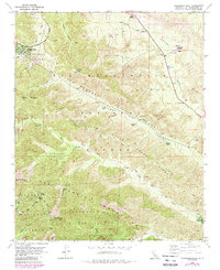
1956 Map of Telegraph Peak
USGS Topo · Published 1988About this map
Wrightwood and the high-altitude landscapes of the Angeles National Forest define this mid-century survey of the eastern San Gabriel Mountains. The map clearly delineates the San Andreas Rift Zone as it cuts through Lone Pine Canyon, a striking geological feature that dominates the central portion of the quadrangle. High peaks like Telegraph Peak, Thunder Mtn, and the iconic Mt Baldy Notch stand over a terrain marked by deep canyons and scattered mountain outposts. Local history is recorded through family-named landmarks such as Nielson Ranch and Clyde Ranch, alongside the Pioneer Historic Marker near the Cajon Basin. The presence of several Prospect labels and a Shaft reflect the region's mining history, while the Angeles Crest Highway provides the primary arterial access through this steep, complex topography.
Find a feature on this map
41 named features on this map. Tap any name to fly to it.
Don’t see what you’re looking for? This feature index may not catch every label — zoom into the map to look around manually.
Map Details
Editions of this 1956 Telegraph Peak Map
4 editions found
Other maps of this area

1896 · San Bernardino
USGS Topo · 1:62,500

1897 · Cucamonga
USGS Topo · 1:62,500

1898 · San Bernardino
USGS Topo · 1:62,500

1900 · Cucamonga
USGS Topo · 1:62,500

1901 · Southern California Sheet No. 1
USGS Topo · 1:250,000

1901 · San Bernardino
USGS Topo · 1:62,500

1902 · Hesperia
USGS Topo · 1:62,500

1903 · Cucamonga
USGS Topo · 1:62,500

1903 · San Antonio
USGS Topo · 1:62,500

1904 · Southern California Sheet No. 1
USGS Topo · 1:250,000