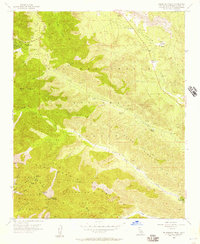
1956 Map of Telegraph Peak
USGS Topo · Published 1957About this map
Wrightwood serves as the primary hub in this mid-century survey of the high mountain divide between the Angeles National Forest and the San Bernardino National Forest. The landscape is dominated by extreme verticality, defined by the towering summit of Telegraph Peak and the high-altitude Mt Baldy Notch. The map details a transition from the developing residential layout in Swarthout Valley to the more primitive reaches of the Cucamonga Wild Area, where only a few remote structures like Manker Flat exist. Historical points of interest appear along the eastern edge, including the Pioneer Historic Marker near Cajon Canyon, signaling the importance of these passes for early transcontinental movement. Scattered mining prospects and ranch outposts such as Prudhon Ranch, Nielson Ranch, and Sharpless Ranch illustrate the sparse but persistent human presence in the drainage basins of Lytle Creek and its various forks.
Find a feature on this map
42 named features on this map. Tap any name to fly to it.
Don’t see what you’re looking for? This feature index may not catch every label — zoom into the map to look around manually.
Map Details
Editions of this 1956 Telegraph Peak Map
4 editions found
Other maps of this area

1896 · San Bernardino
USGS Topo · 1:62,500

1897 · Cucamonga
USGS Topo · 1:62,500

1898 · San Bernardino
USGS Topo · 1:62,500

1900 · Cucamonga
USGS Topo · 1:62,500

1901 · Southern California Sheet No. 1
USGS Topo · 1:250,000

1901 · San Bernardino
USGS Topo · 1:62,500

1902 · Hesperia
USGS Topo · 1:62,500

1903 · Cucamonga
USGS Topo · 1:62,500

1903 · San Antonio
USGS Topo · 1:62,500

1904 · Southern California Sheet No. 1
USGS Topo · 1:250,000