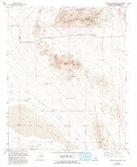
1955 Map of Shadow Mountains
USGS Topo · Published 1993About this map
Shadow Mountains dominate this high-desert landscape in San Bernardino County, where mining and recreation intersect across the arid terrain. The map captures a detailed inventory of resource extraction through numerous shafts, tunnels, and specific claims like the Rabbit Hole Mine and Princess Pat Mine. These workings are concentrated along the northern ridges near Silver Peak, suggesting a period of significant prospecting. In the lower elevations, the vast expanse of El Mirage Lake and its surrounding dry lakes provide a stark contrast to the rocky heights. The transition of the land is evident in the designation of the Off Highway Vehicle Recreation Area, while traces of earlier settlement persist at Hess Ranch (Site). Aviation and local infrastructure are represented by El Mirage Field and the Radio Tower near the northern boundary, while roads like Green Bush Road provide access through the valley.
Find a feature on this map
22 named features on this map. Tap any name to fly to it.
Don’t see what you’re looking for? This feature index may not catch every label — zoom into the map to look around manually.
Map Details
Editions of this 1955 Shadow Mountains Map
4 editions found
Other maps of this area

1930 · El Mirage
USGS Topo · 1:24,000

1931 · Adobe
USGS Topo · 1:24,000

1932 · Barstow
USGS Topo · 1:125,000

1933 · El Mirage
USGS Topo · 1:24,000

1934 · Barstow
USGS Topo · 1:125,000

1934 · Adobe
USGS Topo · 1:24,000

1937 · Shadow Mountains
USGS Topo · 1:48,000

1937 · Kramer
USGS Topo · 1:48,000

1942 · Kramer
USGS Topo · 1:62,500

1942 · Shadow Mountains
USGS Topo · 1:62,500