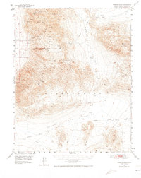
1950 Map of Wingate Pass
USGS Topo · Published 1973About this map
The Panamint Range and Slate Range define this high-desert landscape in the years following World War II, a region shaped by extractive industry and the difficult search for water. Numerous mining claims are scattered across the canyons, including the Sandora Mine, Virginia Ann Mine, and the Lake View Mine. Near the New York Canyon, the presence of Deans Mill suggests a localized hub for ore processing, while the precarious nature of life in the desert is highlighted by the warning at Lone Willow Spring (undrinkable).
Find a feature on this map
29 named features on this map. Tap any name to fly to it.
Don’t see what you’re looking for? This feature index may not catch every label — zoom into the map to look around manually.
Map Details
Editions of this 1950 Wingate Pass Map
3 editions found

Other maps of this area

1915 · Searles Lake
USGS Topo · 1:250,000

1933 · Avawatz Mountains
USGS Topo · 1:250,000

1947 · Trona
USGS Topo · 1:250,000

1948 · Trona
USGS Topo · 1:250,000

1948 · Quail Mountains
USGS Topo · 1:62,500

1948 · Goldstone Lake
USGS Topo · 1:62,500

1949 · Trona
USGS Topo · 1:62,500

1949 · Searles Lake
USGS Topo · 1:62,500

1950 · Searles Lake
USGS Topo · 1:62,500

1950 · Trona
USGS Topo · 1:62,500