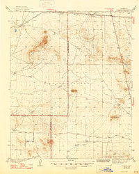
1942 Map of Kramer
USGS Topo · Published 1947About this map
The Atchison Topeka and Santa Fe railroad defines the northern corridor of this desert landscape, linking the small desert outposts of Kramer, Amargo, and Rich. Surveyed in the 1930s, the map illustrates a sparsely populated section of the Mojave Desert where the high desert floor meets distinctive volcanic landforms like Haystack Butte and the Red Buttes. The transition between San Bernardino, Kern, and Los Angeles counties is marked by a nascent grid of roads including Avenue C and Avenue D, which push into the Mirage Valley south of the Shadow Mountains. Isolated homesteads and local infrastructure, such as the Blake Ranch and a remote Airport, represent the early 20th-century effort to establish a presence in this arid environment before the post-war expansion of inland California.
Find a feature on this map
17 named features on this map. Tap any name to fly to it.
Don’t see what you’re looking for? This feature index may not catch every label — zoom into the map to look around manually.
Map Details
Editions of this 1942 Kramer Map
2 editions found

Other maps of this area

1915 · Searles Lake
USGS Topo · 1:250,000

1931 · Adobe
USGS Topo · 1:24,000

1931 · Hi Vista
USGS Topo · 1:24,000

1932 · Barstow
USGS Topo · 1:125,000

1934 · Barstow
USGS Topo · 1:125,000

1934 · Adobe
USGS Topo · 1:24,000

1935 · Hi Vista
USGS Topo · 1:24,000

1937 · Shadow Mountains
USGS Topo · 1:48,000

1937 · Kramer
USGS Topo · 1:48,000

1937 · Rogers Lake
USGS Topo · 1:48,000