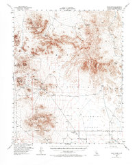
1954 Map of Pilot Knob
USGS Topo · Published 1973About this map
Robbers Mountain and the jagged Eagle Crags dominate this high-desert landscape in the northern Mojave, mapped during a period of transition for the Naval Reservation. The presence of Copper City (Site) and scattered Mines near Granite Mtn point to an era of hard-rock prospecting that once defined these remote ranges. Water is the primary driver of human activity here, evidenced by a network of vital sources including Blue Chalcedony Spring, Moonshine Spring, and Lead Pipe Spring.
Find a feature on this map
28 named features on this map. Tap any name to fly to it.
Don’t see what you’re looking for? This feature index may not catch every label — zoom into the map to look around manually.
Map Details
Editions of this 1954 Pilot Knob Map
3 editions found

Other maps of this area

1915 · Searles Lake
USGS Topo · 1:250,000

1933 · Avawatz Mountains
USGS Topo · 1:250,000

1947 · Trona
USGS Topo · 1:250,000

1948 · Trona
USGS Topo · 1:250,000

1948 · Quail Mountains
USGS Topo · 1:62,500

1948 · Lane Mountain
USGS Topo · 1:62,500

1948 · Goldstone Lake
USGS Topo · 1:62,500

1949 · Searles Lake
USGS Topo · 1:62,500

1950 · Searles Lake
USGS Topo · 1:62,500

1950 · Wingate Pass
USGS Topo · 1:62,500