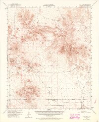
1954 Map of Pilot Knob
USGS Topo · Published 1964About this map
The high desert landscape of San Bernardino County is defined here by the intersection of early mining history and mid-century military operations. Much of the northern and eastern terrain is dominated by the Naval Reservation, a designation that overlays a network of older land uses and geological landmarks. Remnants of prospecting and pioneer life are evident at the Copper City (Site) and the P K Ranch, located near the base of prominent peaks like Pilot Knob and Granite Mtn.
Find a feature on this map
27 named features on this map. Tap any name to fly to it.
Don’t see what you’re looking for? This feature index may not catch every label — zoom into the map to look around manually.
Map Details
Editions of this 1954 Pilot Knob Map
3 editions found

Other maps of this area

1915 · Searles Lake
USGS Topo · 1:250,000

1933 · Avawatz Mountains
USGS Topo · 1:250,000

1947 · Trona
USGS Topo · 1:250,000

1948 · Trona
USGS Topo · 1:250,000

1948 · Quail Mountains
USGS Topo · 1:62,500

1948 · Lane Mountain
USGS Topo · 1:62,500

1948 · Goldstone Lake
USGS Topo · 1:62,500

1949 · Searles Lake
USGS Topo · 1:62,500

1950 · Searles Lake
USGS Topo · 1:62,500

1950 · Wingate Pass
USGS Topo · 1:62,500