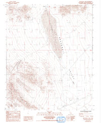
1984 Map of Broadwell Lake
USGS Topo · Published 1993About this map
Broadwell Lake occupies the center of this high-desert landscape, a dry basin situated between the Cady Mountains and the Bristol Mountains. The map reveals a transition from natural landforms to industrial infrastructure, characterized by the Old Railroad Grade and a Steel Tower Transmission Line cutting across the Broadwell Valley. Evidence of the region's mining history is found in the foothills, where the Old Dominion Mine and Lavic Mtn Mine are situated near several prospect sites. While the Broadwell (Site) indicates where human settlement once concentrated, the later 20th-century landscape is dominated by utility corridors, including the Argos Pipeline. This survey captures a remote Mojave drainage system defined by shifting washes and mountain slopes.
Find a feature on this map
12 named features on this map. Tap any name to fly to it.
Don’t see what you’re looking for? This feature index may not catch every label — zoom into the map to look around manually.
Map Details
Editions of this 1984 Broadwell Lake Map
2 editions found
Other maps of this area

1953 · San Bernardino
USGS Topo · 1:250,000

1955 · Ludlow
USGS Topo · 1:24,000

1955 · Ash Hill
USGS Topo · 1:24,000

1955 · Lavic Lake
USGS Topo · 1:24,000

1955 · Lavic
USGS Topo · 1:62,500

1955 · Cady Mountains
USGS Topo · 1:62,500

1955 · Broadwell Lake
USGS Topo · 1:62,500

1955 · Ludlow
USGS Topo · 1:62,500

1956 · San Bernardino
USGS Topo · 1:250,000

1957 · San Bernardino
USGS Topo · 1:250,000