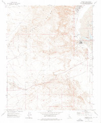
1973 Map of Westend
USGS Topo · Published 1976About this map
Industrial operations along the western edge of Searles Lake define this 1970s landscape, where the extraction of minerals from the dry lake bed shaped the local economy. The settlements of Argus, South Trona, and Westend are clustered along the Trona Railway, supporting the complex network of Industrial Waste Ponds, tailings, and an aqueduct that fueled desert industry. Further west, the terrain rises into the Argus Range, much of which falls within the restricted boundaries of the China Lake Naval Weapons Center. A fascinating relic of earlier transportation history is visible in the Dismantled Monorail trace near the Salt Well. From the historic Borosolvay location to the winding path of Poison Canyon, the map illustrates a rugged intersection of military reservation, specialized mining, and remote desert outposts like Skytop.
Find a feature on this map
32 named features on this map. Tap any name to fly to it.
Don’t see what you’re looking for? This feature index may not catch every label — zoom into the map to look around manually.
Map Details
Editions of this 1973 Westend Map
This is the sole edition of this map. No revisions or reprints were ever made.
Other maps of this area

1915 · Searles Lake
USGS Topo · 1:250,000

1947 · Trona
USGS Topo · 1:250,000

1948 · Trona
USGS Topo · 1:250,000

1949 · Trona
USGS Topo · 1:62,500

1949 · Searles Lake
USGS Topo · 1:62,500

1950 · Searles Lake
USGS Topo · 1:62,500

1950 · Trona
USGS Topo · 1:62,500

1953 · Mountain Springs Canyon
USGS Topo · 1:62,500

1953 · Ridgecrest
USGS Topo · 1:62,500

1953 · Trona
USGS Topo · 1:250,000