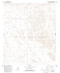
1955 Map of Deadman Lake NW
USGS Topo · Published 1994About this map
Bullion Mountains dominate this arid landscape within the Marine Corps Air Ground Combat Center, a region defined by extensive wash systems and high desert passes. The topography is marked by significant elevation changes, from the heights of Noble Pass in the north to the distinctive Gypsum Ridge in the south. The drainage patterns of Bullion Wash and the geological cuts of Rainbow Canyon and Wood Canyon reveal a terrain shaped by seasonal water flow, even as the area serves as a specialized military training ground. This 1955 survey, based on 1952 aerial photography, captures the primitive road network consisting primarily of 4wd tracks that navigate the interior of the range, offering a clear record of the area's geography before later modern modifications to the combat center's infrastructure.
Find a feature on this map
9 named features on this map. Tap any name to fly to it.
Don’t see what you’re looking for? This feature index may not catch every label — zoom into the map to look around manually.
Map Details
Editions of this 1955 Deadman Lake NW Map
4 editions found
Other maps of this area

1953 · San Bernardino
USGS Topo · 1:250,000

1954 · Hidalgo Mtn
USGS Topo · 1:24,000

1954 · Ludlow SE
USGS Topo · 1:24,000

1955 · Deadman Lake NW
USGS Topo · 1:24,000

1955 · Lavic SE
USGS Topo · 1:24,000

1955 · Goat Mountain
USGS Topo · 1:24,000

1955 · Morgans Well
USGS Topo · 1:24,000

1955 · Deadman Lake SE
USGS Topo · 1:24,000

1955 · Deadman Lake NE
USGS Topo · 1:24,000

1955 · Deadman Lake SW
USGS Topo · 1:24,000