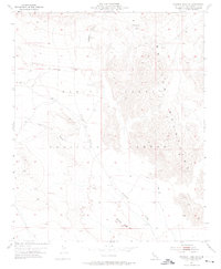
1955 Map of Deadman Lake NW
USGS Topo · Published 1974About this map
The Bullion Mountains dominate this high-desert landscape in San Bernardino County, as recorded during field checks in the mid-1950s. This land was designated as part of the Marine Corps Training Center, a status that has preserved its remote character and limited development. The terrain is defined by dry watercourses and sharp ridges, including Bullion Wash, Rainbow Canyon, and Gypsum Ridge. Navigation across this demanding environment relies on established landmarks like Noble Pass and rugged paths such as the Wood Canyon Trail and various unnamed Jeep Trails. This map serves as an important record of the region's topography before modern military training operations further altered the surface, capturing the natural drainage patterns and elevation contours that shaped the movement of both early travelers and later military personnel.
Find a feature on this map
8 named features on this map. Tap any name to fly to it.
Don’t see what you’re looking for? This feature index may not catch every label — zoom into the map to look around manually.
Map Details
Editions of this 1955 Deadman Lake NW Map
4 editions found
Other maps of this area

1953 · San Bernardino
USGS Topo · 1:250,000

1954 · Hidalgo Mtn
USGS Topo · 1:24,000

1954 · Ludlow SE
USGS Topo · 1:24,000

1955 · Deadman Lake NW
USGS Topo · 1:24,000

1955 · Lavic SE
USGS Topo · 1:24,000

1955 · Goat Mountain
USGS Topo · 1:24,000

1955 · Morgans Well
USGS Topo · 1:24,000

1955 · Deadman Lake SE
USGS Topo · 1:24,000

1955 · Deadman Lake NE
USGS Topo · 1:24,000

1955 · Deadman Lake SW
USGS Topo · 1:24,000