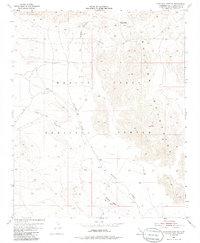
1955 Map of Deadman Lake NW
USGS Topo · Published 1985About this map
The Marine Corps Training Center dominates this high-desert landscape in San Bernardino County, capturing the region during the mid-1950s when military activity and natural landforms defined the area's use. The topographic relief is punctuated by the Bullion Mountains and the sharp elevation change at Noble Pass. A network of drainage patterns, including the wide Bullion Wash and the distinct carved routes of Rainbow Canyon and Wood Canyon, illustrates the arid hydrology of the Mojave. A solitary Jeep Trail provides the primary evidence of human transit through this training ground, connecting the lower flats with the ascending terrain of Gypsum Ridge. The map highlights the transition from alluvial fans to jagged peaks, providing a clear record of the area's physical geography before later 20th-century developments changed the intensity of its tactical use.
Find a feature on this map
9 named features on this map. Tap any name to fly to it.
Don’t see what you’re looking for? This feature index may not catch every label — zoom into the map to look around manually.
Map Details
Editions of this 1955 Deadman Lake NW Map
4 editions found
Other maps of this area

1953 · San Bernardino
USGS Topo · 1:250,000

1954 · Hidalgo Mtn
USGS Topo · 1:24,000

1954 · Ludlow SE
USGS Topo · 1:24,000

1955 · Deadman Lake NW
USGS Topo · 1:24,000

1955 · Lavic SE
USGS Topo · 1:24,000

1955 · Goat Mountain
USGS Topo · 1:24,000

1955 · Morgans Well
USGS Topo · 1:24,000

1955 · Deadman Lake SE
USGS Topo · 1:24,000

1955 · Deadman Lake NE
USGS Topo · 1:24,000

1955 · Deadman Lake SW
USGS Topo · 1:24,000