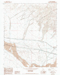
1982 Map of Hector
USGS Topo · Published 1992About this map
The settlement of Hector serves as a central point in this Mojave Desert corridor, where infrastructure and resource extraction define the landscape. Extensive Strip Mines and an Open Pit Mine indicate the industrial activity that sustained the local economy during this era, while the presence of a Radio Facility and Sub Sta highlight the area's role in regional communication and power distribution.
Find a feature on this map
16 named features on this map. Tap any name to fly to it.
Don’t see what you’re looking for? This feature index may not catch every label — zoom into the map to look around manually.
Map Details
Editions of this 1982 Hector Map
2 editions found
Other maps of this area

1953 · San Bernardino
USGS Topo · 1:250,000

1955 · Silver Bell Mine
USGS Topo · 1:24,000

1955 · Sunshine Peak
USGS Topo · 1:24,000

1955 · Lavic Lake
USGS Topo · 1:24,000

1955 · Newberry
USGS Topo · 1:62,500

1955 · Lavic
USGS Topo · 1:62,500

1955 · Cady Mountains
USGS Topo · 1:62,500

1955 · Rodman Mountains
USGS Topo · 1:62,500

1956 · San Bernardino
USGS Topo · 1:250,000

1957 · San Bernardino
USGS Topo · 1:250,000