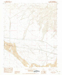
1982 Map of Hector
USGS Topo · Published 1982About this map
The Cady Mountains dominate the northern landscape of this Mojave Desert region, where industrial extraction and transportation infrastructure intersect. The small settlement of Hector serves as a focal point along the Atchison Topeka and Santa Fe railroad, a vital corridor for freight movement across the arid terrain. The map reveals a high concentration of mining activity, including the Hector Mine, various Strip Mines, and an Open Pit Mine, indicating the area's significance for mineral production in the early 1980s.
Find a feature on this map
16 named features on this map. Tap any name to fly to it.
Don’t see what you’re looking for? This feature index may not catch every label — zoom into the map to look around manually.
Map Details
Editions of this 1982 Hector Map
2 editions found
Other maps of this area

1953 · San Bernardino
USGS Topo · 1:250,000

1955 · Silver Bell Mine
USGS Topo · 1:24,000

1955 · Sunshine Peak
USGS Topo · 1:24,000

1955 · Lavic Lake
USGS Topo · 1:24,000

1955 · Newberry
USGS Topo · 1:62,500

1955 · Lavic
USGS Topo · 1:62,500

1955 · Cady Mountains
USGS Topo · 1:62,500

1955 · Rodman Mountains
USGS Topo · 1:62,500

1956 · San Bernardino
USGS Topo · 1:250,000

1957 · San Bernardino
USGS Topo · 1:250,000