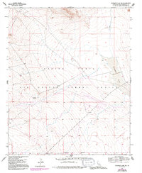
1955 Map of Deadman Lake SW
USGS Topo · Published 1994About this map
Marine Corps Air Ground Combat Center dominates this high-desert landscape in San Bernardino County, where military operations and natural desert hydrology meet. Based on a 1954 plane-table survey and updated with purple-ink revisions from the late 1970s, the map reveals the critical infrastructure of the Naval Reservation Boundary. The presence of the Landing Field positioned adjacent to the dry bed of Deadman Lake illustrates the strategic use of flat, arid basins for aviation during the mid-20th century. Water, though scarce, is represented by Surprise Spring, a vital point of interest for anyone studying the historic distribution of resources in this remote training ground. The topographic contours highlight the transition from the lakebed floor to the surrounding mountainous terrain, providing a clear record of the area's geography before more modern developments within the base complex.
Find a feature on this map
6 named features on this map. Tap any name to fly to it.
Don’t see what you’re looking for? This feature index may not catch every label — zoom into the map to look around manually.
Map Details
Editions of this 1955 Deadman Lake SW Map
5 editions found
Other maps of this area

1953 · San Bernardino
USGS Topo · 1:250,000

1954 · Hidalgo Mtn
USGS Topo · 1:24,000

1955 · Deadman Lake NW
USGS Topo · 1:24,000

1955 · Goat Mountain
USGS Topo · 1:24,000

1955 · Deadman Lake SE
USGS Topo · 1:24,000

1955 · Deadman Lake NE
USGS Topo · 1:24,000

1955 · Deadman Lake SW
USGS Topo · 1:24,000

1955 · Twentynine Palms
USGS Topo · 1:24,000

1955 · Twentynine Palms
USGS Topo · 1:62,500

1955 · Emerson Lake
USGS Topo · 1:62,500