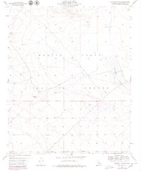
1955 Map of Deadman Lake SW
USGS Topo · Published 1979About this map
The Marine Corps Training Center dominates this high-desert landscape in San Bernardino County, reflecting the area's mid-century role in military readiness. Surveys from the early 1950s detail a stark environment defined by isolated landmarks and expansive training grounds. The presence of a Landing Field and the Naval Reservation Boundary underscores the strategic importance of this terrain for aviation and tactical maneuvers.
Find a feature on this map
9 named features on this map. Tap any name to fly to it.
Don’t see what you’re looking for? This feature index may not catch every label — zoom into the map to look around manually.
Map Details
Editions of this 1955 Deadman Lake SW Map
5 editions found
Other maps of this area

1953 · San Bernardino
USGS Topo · 1:250,000

1954 · Hidalgo Mtn
USGS Topo · 1:24,000

1955 · Deadman Lake NW
USGS Topo · 1:24,000

1955 · Goat Mountain
USGS Topo · 1:24,000

1955 · Deadman Lake SE
USGS Topo · 1:24,000

1955 · Deadman Lake NE
USGS Topo · 1:24,000

1955 · Deadman Lake SW
USGS Topo · 1:24,000

1955 · Twentynine Palms
USGS Topo · 1:24,000

1955 · Twentynine Palms
USGS Topo · 1:62,500

1955 · Emerson Lake
USGS Topo · 1:62,500