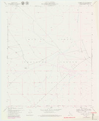
1955 Map of Deadman Lake SW
USGS Topo · Published 1979About this map
Marine Corps Training Center dominates this high-desert landscape in San Bernardino County, a terrain defined by arid basins and isolated water sources. The presence of Surprise Spring and the dry expanse of Deadman Lake highlight the critical role of sparse water points in this desert environment. Revisions from 1976, marked in purple, show the evolving military infrastructure of the late twentieth century, specifically around the Landing Field. A network of Jeep Trails crisscrosses the topography, illustrating how accessibility in these remote reaches was maintained for training and observation. The map also delineates the Naval Reservation Boundary, marking the intersection of different federal land uses during a period of significant military presence in the California interior.
Find a feature on this map
6 named features on this map. Tap any name to fly to it.
Don’t see what you’re looking for? This feature index may not catch every label — zoom into the map to look around manually.
Map Details
Editions of this 1955 Deadman Lake SW Map
5 editions found
Other maps of this area

1953 · San Bernardino
USGS Topo · 1:250,000

1954 · Hidalgo Mtn
USGS Topo · 1:24,000

1955 · Deadman Lake NW
USGS Topo · 1:24,000

1955 · Goat Mountain
USGS Topo · 1:24,000

1955 · Deadman Lake SE
USGS Topo · 1:24,000

1955 · Deadman Lake NE
USGS Topo · 1:24,000

1955 · Deadman Lake SW
USGS Topo · 1:24,000

1955 · Twentynine Palms
USGS Topo · 1:24,000

1955 · Twentynine Palms
USGS Topo · 1:62,500

1955 · Emerson Lake
USGS Topo · 1:62,500