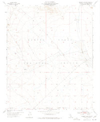
1955 Map of Deadman Lake SW
USGS Topo · Published 1975About this map
The arid landscape of San Bernardino County is dominated by the sprawling operations of the Marine Corps Training Center in the mid-1950s. This survey, conducted during the administration of Governor Goodwin J. Knight, illustrates the intersection of military utility and desert topography. The eastern edge of the map features the dry basin of Deadman Lake, an expansive alkali flat accompanied by a remote Landing Field. Such features were essential for training exercises in the post-war era, providing the open space necessary for maneuvers and aviation.
Find a feature on this map
8 named features on this map. Tap any name to fly to it.
Don’t see what you’re looking for? This feature index may not catch every label — zoom into the map to look around manually.
Map Details
Editions of this 1955 Deadman Lake SW Map
5 editions found
Other maps of this area

1953 · San Bernardino
USGS Topo · 1:250,000

1954 · Hidalgo Mtn
USGS Topo · 1:24,000

1955 · Deadman Lake NW
USGS Topo · 1:24,000

1955 · Goat Mountain
USGS Topo · 1:24,000

1955 · Deadman Lake SE
USGS Topo · 1:24,000

1955 · Deadman Lake NE
USGS Topo · 1:24,000

1955 · Deadman Lake SW
USGS Topo · 1:24,000

1955 · Twentynine Palms
USGS Topo · 1:24,000

1955 · Twentynine Palms
USGS Topo · 1:62,500

1955 · Emerson Lake
USGS Topo · 1:62,500