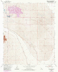
1954 Map of Bristol Lake NW
USGS Topo · Published 1985About this map
Salt Evaporators dominate the northwestern basin of Bristol Lake, showing a complex system of extraction ponds and channels in the San Bernardino desert. These industrial features are highlighted by revisions from the mid-1980s, layered over the original 1954 topography. The map illustrates a landscape of extreme utility, where the barren salt pan is partitioned for resource harvesting. To the southwest, the boundary of the Marine Corps Air Ground Combat Center encroaches upon the alluvial fans of the nearby mountains, marking the transition from industrial salt production to military training territory. Transportation through this arid expanse is anchored by Amboy Road, which skirts the edge of the lake bed. Scattered mining activity, including various prospects and a Gravel Pit, indicates the broader mineral interest in the area beyond the salt works.
Find a feature on this map
8 named features on this map. Tap any name to fly to it.
Don’t see what you’re looking for? This feature index may not catch every label — zoom into the map to look around manually.
Map Details
Editions of this 1954 Bristol Lake NW Map
4 editions found
Other maps of this area

1942 · Amboy
USGS Topo · 1:250,000

1943 · Amboy
USGS Topo · 1:250,000

1954 · Needles
USGS Topo · 1:250,000

1954 · Bristol Lake NW
USGS Topo · 1:24,000

1954 · Amboy Crater
USGS Topo · 1:24,000

1954 · Bristol Lake SW
USGS Topo · 1:24,000

1955 · Lead Mtn. NE
USGS Topo · 1:24,000
1955 · Cleghorn Lakes
USGS Topo · 1:24,000

1955 · Lead Mountain
USGS Topo · 1:62,500

1956 · Needles
USGS Topo · 1:250,000