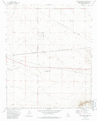
1973 Map of Twelve Gauge Lake
USGS Topo · Published 1985About this map
Hawes Auxiliary Airport stands as a prominent fixture in this Mojave Desert landscape, reflecting the region's mid-century aviation infrastructure. The terrain is defined by wide basins like Water Valley and the dry bed of Twelve Gauge Lake, set against the rising slopes of Iron Mountain to the southeast. A grid of planned roads, including Phoenix Rd, Salinas Rd, and El Centro Rd, suggests an era of desert land development and partitioning during the early 1970s. Industrial activity is evidenced by several Mine and Prospect sites scattered across the flats, while major utility corridors marked by pipelines and the Atchison Topeka and Santa Fe railroad traverse the quadrangle. This survey captures a moment when traditional desert transit routes like Harper Lake Road and Helendale Road intersected with modern industrial and military expansion.
Find a feature on this map
15 named features on this map. Tap any name to fly to it.
Don’t see what you’re looking for? This feature index may not catch every label — zoom into the map to look around manually.
Map Details
Editions of this 1973 Twelve Gauge Lake Map
3 editions found
Other maps of this area

1915 · Searles Lake
USGS Topo · 1:250,000

1932 · Barstow
USGS Topo · 1:125,000

1934 · Barstow
USGS Topo · 1:125,000

1947 · Trona
USGS Topo · 1:250,000

1948 · Trona
USGS Topo · 1:250,000

1953 · San Bernardino
USGS Topo · 1:250,000

1953 · Trona
USGS Topo · 1:250,000

1955 · Opal Mountain
USGS Topo · 1:62,500

1956 · San Bernardino
USGS Topo · 1:250,000

1956 · Fremont Peak
USGS Topo · 1:62,500