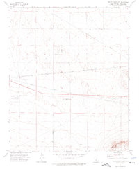
1973 Map of Twelve Gauge Lake
USGS Topo · Published 1976About this map
Twelve Gauge Lake and the surrounding high desert of San Bernardino County are captured here in the early 1970s, showcasing a landscape defined by industrial infrastructure and topographic extremes. The Atchison Topeka and Santa Fe railroad corridor cuts across the center of the sheet, paralleled by significant Pipelines that underscore the region's role as a transit and utility artery. To the south, the terrain rises sharply toward the slopes of Iron Mountain, while the northern reaches open into the flats of Water Valley. Scattered Mine symbols and various Prospect sites suggest ongoing mineral exploration in the arid soils. Human presence is otherwise marked by specialized facilities like the Hawes Auxillary Airport and a network of desert thoroughfares including Harper Lake Road and Helendale Rd.
Find a feature on this map
17 named features on this map. Tap any name to fly to it.
Don’t see what you’re looking for? This feature index may not catch every label — zoom into the map to look around manually.
Map Details
Editions of this 1973 Twelve Gauge Lake Map
3 editions found
Other maps of this area

1915 · Searles Lake
USGS Topo · 1:250,000

1932 · Barstow
USGS Topo · 1:125,000

1934 · Barstow
USGS Topo · 1:125,000

1947 · Trona
USGS Topo · 1:250,000

1948 · Trona
USGS Topo · 1:250,000

1953 · San Bernardino
USGS Topo · 1:250,000

1953 · Trona
USGS Topo · 1:250,000

1955 · Opal Mountain
USGS Topo · 1:62,500

1956 · San Bernardino
USGS Topo · 1:250,000

1956 · Fremont Peak
USGS Topo · 1:62,500