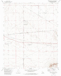
1973 Map of Twelve Guage Lake
USGS Topo · Published 1985About this map
Twelve Gauge Lake and the settlement of Harper define this arid stretch of the High Desert during the early 1970s. The landscape is a study in industrial and transportation corridors, dominated by the heavy rail infrastructure of the Atchison Topeka and Santa Fe railroad and a network of high-pressure Pipelines cutting across the basin. To the southwest, the Hawes Auxiliary Airport remains a prominent landmark of military and aviation history, situated near several Mines and Prospects that pepper the terrain. In the southeast, the slopes of Iron Mountain rise above the valley floor, where a grid of rural roads like Phoenix Rd and Salinas Rd connect scattered Wells and Dry Wells, reflecting the challenges of desert water management and land use during this era.
Find a feature on this map
22 named features on this map. Tap any name to fly to it.
Don’t see what you’re looking for? This feature index may not catch every label — zoom into the map to look around manually.
Map Details
Editions of this 1973 Twelve Guage Lake Map
3 editions found
Other maps of this area

1915 · Searles Lake
USGS Topo · 1:250,000

1932 · Barstow
USGS Topo · 1:125,000

1934 · Barstow
USGS Topo · 1:125,000

1947 · Trona
USGS Topo · 1:250,000

1948 · Trona
USGS Topo · 1:250,000

1953 · San Bernardino
USGS Topo · 1:250,000

1953 · Trona
USGS Topo · 1:250,000

1955 · Opal Mountain
USGS Topo · 1:62,500

1956 · San Bernardino
USGS Topo · 1:250,000

1956 · Fremont Peak
USGS Topo · 1:62,500