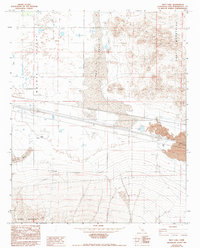
1982 Map of Troy Lake
USGS Topo · Published 1993About this map
Troy Lake and the arid expanse of the Mojave Valley dominate this High Desert landscape during the early 1980s. The map illustrates a harsh environment shaped by geological forces, evidenced by the expansive Lava flows spreading south from the Cady Mountains. Infrastructure in this remote stretch of San Bernardino County is sparse, characterized primarily by an underground gas pipeline and a series of levees designed to manage seasonal water flow toward the Dry Lake basins.
Find a feature on this map
19 named features on this map. Tap any name to fly to it.
Don’t see what you’re looking for? This feature index may not catch every label — zoom into the map to look around manually.
Map Details
Editions of this 1982 Troy Lake Map
3 editions found
Other maps of this area

1953 · San Bernardino
USGS Topo · 1:250,000

1955 · Silver Bell Mine
USGS Topo · 1:24,000

1955 · Sunshine Peak
USGS Topo · 1:24,000

1955 · Newberry
USGS Topo · 1:62,500

1955 · Lavic
USGS Topo · 1:62,500

1955 · Cady Mountains
USGS Topo · 1:62,500

1955 · Rodman Mountains
USGS Topo · 1:62,500

1956 · San Bernardino
USGS Topo · 1:250,000

1957 · San Bernardino
USGS Topo · 1:250,000

1958 · San Bernardino
USGS Topo · 1:250,000