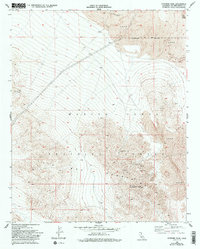
1955 Map of Sunshine Peak
USGS Topo · Published 1992About this map
Sunshine Peak dominates this volcanic landscape in the Mojave Desert, where geologically recent activity is etched across the terrain in the form of widespread Lava flows. The northeastern corner is anchored by Pisgah Crater, a prominent cinder cone that stands as a landmark amidst the basaltic fields. This 1955 survey illustrates a mid-century transition in land use, showing the overlap between traditional extraction and burgeoning military activity. Hardrock mining interest is evident through several named claims, including the National Lead Mine and Silver Cliff Mine. These industrial sites are juxtaposed against the expanding Marine Corps Training Center and the Naval Reservation Boundary, indicating the shift toward the region's importance for defense operations. Scattered water sources like a lone Spring and various Prospect sites underscore the challenges of life and labor in this arid high-desert environment.
Find a feature on this map
12 named features on this map. Tap any name to fly to it.
Don’t see what you’re looking for? This feature index may not catch every label — zoom into the map to look around manually.
Map Details
Editions of this 1955 Sunshine Peak Map
5 editions found
Other maps of this area

1953 · San Bernardino
USGS Topo · 1:250,000

1954 · Galway Lake
USGS Topo · 1:24,000

1955 · Lavic SE
USGS Topo · 1:24,000

1955 · Silver Bell Mine
USGS Topo · 1:24,000

1955 · Sunshine Peak
USGS Topo · 1:24,000

1955 · Lavic Lake
USGS Topo · 1:24,000

1955 · Newberry
USGS Topo · 1:62,500

1955 · Lavic
USGS Topo · 1:62,500

1955 · Cady Mountains
USGS Topo · 1:62,500

1955 · Rodman Mountains
USGS Topo · 1:62,500