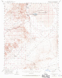
1949 Map of Searles Lake
USGS Topo · Published 1971About this map
Industrial mineral extraction and desert infrastructure define this high-desert landscape just after the war. The presence of settlements like Argus, Borosolvay, and South Trona along the western edge of Searles Lake illustrates the intense salt and potash mining operations of the era. To the north, Sediment tanks and various pipeline networks connect these remote outposts to the surrounding terrain, while a Dismantled RR traces the historical movement of materials before transportation patterns shifted.
Find a feature on this map
25 named features on this map. Tap any name to fly to it.
Don’t see what you’re looking for? This feature index may not catch every label — zoom into the map to look around manually.
Map Details
Editions of this 1949 Searles Lake Map
3 editions found
Other maps of this area

1903 · Randsburg
USGS Topo · 1:62,500

1911 · Randsburg
USGS Topo · 1:62,500

1912 · Randsburg
USGS Topo · 1:62,500

1915 · Searles Lake
USGS Topo · 1:250,000

1947 · Trona
USGS Topo · 1:250,000

1948 · Trona
USGS Topo · 1:250,000

1949 · Trona
USGS Topo · 1:62,500

1949 · Searles Lake
USGS Topo · 1:62,500

1950 · Searles Lake
USGS Topo · 1:62,500

1950 · Trona
USGS Topo · 1:62,500