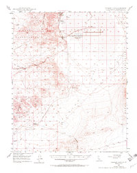
1949 Map of Searles Lake
USGS Topo · Published 1971About this map
Searles Lake dominates this mid-century topographic record, capturing the industrial and geological landscape of the San Bernardino desert. The map reveals a cluster of company towns and chemical processing sites along the western shore, including Argus, Borosolvay, South Trona, and Westend. These settlements, tied to the mineral extraction from the dry lake bed, sit at the foot of the Argus Range, which rises sharply to the west. Evidence of the area's shifting infrastructure is seen in a Dismantled R.R. stretching across the basin, reflecting the changing fortunes of desert mining.
Find a feature on this map
23 named features on this map. Tap any name to fly to it.
Don’t see what you’re looking for? This feature index may not catch every label — zoom into the map to look around manually.
Map Details
Editions of this 1949 Searles Lake Map
3 editions found
Other maps of this area

1903 · Randsburg
USGS Topo · 1:62,500

1911 · Randsburg
USGS Topo · 1:62,500

1912 · Randsburg
USGS Topo · 1:62,500

1915 · Searles Lake
USGS Topo · 1:250,000

1947 · Trona
USGS Topo · 1:250,000

1948 · Trona
USGS Topo · 1:250,000

1949 · Trona
USGS Topo · 1:62,500

1949 · Searles Lake
USGS Topo · 1:62,500

1950 · Searles Lake
USGS Topo · 1:62,500

1950 · Trona
USGS Topo · 1:62,500