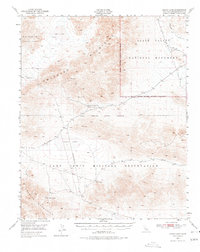
1948 Map of Leach Lake
USGS Topo · Published 1978About this map
The Owlshead Mountains and Granite Mountains dominate this 1948 topographic study, showcasing a remote California landscape defined by mineral extraction and military expansion. Mining history is preserved through the Black Magic Mines and the New Deal Mine, highlighting the era's focus on the region's geologic potential. The northern boundary of the Camp Irwin Military Reservation meets the southern edge of Death Valley National Monument, illustrating the transition from preserved wilderness to active defense training grounds. Water sources are critical landmarks in this arid basin, including the ephemeral Leach Lake and scattered vital points like Owl Hole Springs and Desert King Spring. The presence of the Randsburg Road and the braided course of the Amargosa River provide further evidence of the primitive transportation and drainage networks during the late 1940s.
Find a feature on this map
19 named features on this map. Tap any name to fly to it.
Don’t see what you’re looking for? This feature index may not catch every label — zoom into the map to look around manually.
Map Details
Editions of this 1948 Leach Lake Map
3 editions found
Other maps of this area

1933 · Avawatz Mountains
USGS Topo · 1:250,000

1947 · Trona
USGS Topo · 1:250,000

1948 · Red Pass Lake
USGS Topo · 1:62,500

1948 · Trona
USGS Topo · 1:250,000

1948 · Quail Mountains
USGS Topo · 1:62,500

1948 · Leach Lake
USGS Topo · 1:62,500

1948 · Avawatz Pass
USGS Topo · 1:62,500

1948 · Goldstone Lake
USGS Topo · 1:62,500

1948 · Tiefort Mountains
USGS Topo · 1:62,500

1950 · Wingate Wash
USGS Topo · 1:62,500