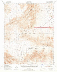
1948 Map of Leach Lake
USGS Topo · Published 1966About this map
Black Magic Mines and the New Deal Mine represent the industrial footprint of this remote desert landscape during the late 1940s. The terrain is defined by the high peaks of the Owlshead Mountains and the Granite Mountains, punctuated by crucial water sources like Owl Hole Springs, Two Springs, and Desert King Spring. These springs provided the only reliable water for prospectors and travelers moving along the Randsburg Road towards the northwestern corners of the San Bernardino desert.
Find a feature on this map
16 named features on this map. Tap any name to fly to it.
Don’t see what you’re looking for? This feature index may not catch every label — zoom into the map to look around manually.
Map Details
Editions of this 1948 Leach Lake Map
3 editions found
Other maps of this area

1933 · Avawatz Mountains
USGS Topo · 1:250,000

1947 · Trona
USGS Topo · 1:250,000

1948 · Red Pass Lake
USGS Topo · 1:62,500

1948 · Trona
USGS Topo · 1:250,000

1948 · Quail Mountains
USGS Topo · 1:62,500

1948 · Leach Lake
USGS Topo · 1:62,500

1948 · Avawatz Pass
USGS Topo · 1:62,500

1948 · Goldstone Lake
USGS Topo · 1:62,500

1948 · Tiefort Mountains
USGS Topo · 1:62,500

1950 · Wingate Wash
USGS Topo · 1:62,500