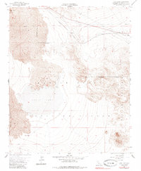
1955 Map of Lavic Lake
USGS Topo · Published 1985About this map
Lavic Lake dominates this high-desert basin, its dry expanse situated between the Lava Bed Mountains and the Bullion Mountains. The mid-1950s landscape shows a corridor of infrastructure cutting through the volcanic terrain, headlined by the Atchison Topeka and Santa Fe railroad and the famed Route 66. Small railroad sidings at Lavic and Argos provide evidence of the era's desert outposts, while an Airway Beacon and a nearby Landing Field mark the importance of aerial navigation in this remote stretch of San Bernardino County.
Find a feature on this map
19 named features on this map. Tap any name to fly to it.
Don’t see what you’re looking for? This feature index may not catch every label — zoom into the map to look around manually.
Map Details
Editions of this 1955 Lavic Lake Map
3 editions found
Other maps of this area

1953 · San Bernardino
USGS Topo · 1:250,000

1954 · Galway Lake
USGS Topo · 1:24,000

1955 · Ludlow
USGS Topo · 1:24,000

1955 · Lavic SE
USGS Topo · 1:24,000

1955 · Morgans Well
USGS Topo · 1:24,000

1955 · Sunshine Peak
USGS Topo · 1:24,000

1955 · Lavic Lake
USGS Topo · 1:24,000

1955 · Lavic
USGS Topo · 1:62,500

1955 · Cady Mountains
USGS Topo · 1:62,500

1955 · Broadwell Lake
USGS Topo · 1:62,500