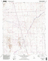
1956 Map of Victorville NW
USGS Topo · Published 1993About this map
Shadow Mountains and the Shadow Hills dominate this portion of the Mojave Desert, where mining and recreation define the use of the arid land. The map reveals a history of extraction through the presence of the Red Raven Mine and various Prospects scattered across the desert slopes. This 1956 survey, updated with 1989 aerial data, shows the expansion of the Adelanto Corporate Boundary and the establishment of the El Mirage Off Highway Vehicle Recreation Area, marking a shift from industrial mining to modern motorized leisure.
Find a feature on this map
19 named features on this map. Tap any name to fly to it.
Don’t see what you’re looking for? This feature index may not catch every label — zoom into the map to look around manually.
Map Details
Editions of this 1956 Victorville NW Map
6 editions found
Other maps of this area

1932 · Barstow
USGS Topo · 1:125,000

1934 · Barstow
USGS Topo · 1:125,000

1937 · Shadow Mountains
USGS Topo · 1:48,000

1937 · Kramer
USGS Topo · 1:48,000

1942 · Kramer
USGS Topo · 1:62,500

1942 · Shadow Mountains
USGS Topo · 1:62,500

1947 · Red Buttes
USGS Topo · 1:24,000

1953 · San Bernardino
USGS Topo · 1:250,000
1955 · Shadow Mountains
USGS Topo · 1:24,000
1955 · Shadow Mountains SE
USGS Topo · 1:24,000