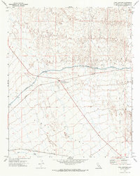
1971 Map of Vidal Junction
USGS Topo · Published 1973About this map
Vidal Junction serves as a critical desert crossroads in the eastern Mojave, anchored by its Plant Quarantine Station and the intersection of major transit lines. The 1971 landscape is defined by the massive infrastructure of the Colorado River Aqueduct, which cuts across the terrain with a series of siphons. To the south, the settlement of Vidal sits along the Atchison Topeka and Santa Fe railroad, marking a point of transition into the broad Vidal Valley. The map reveals a network of desert mobility, from the established Chambers Well Road to various Jeep Trails and a local Landing Strip, illustrating how industrial water transport and rail logistics shaped this corner of San Bernardino County during the early 1970s.
Find a feature on this map
10 named features on this map. Tap any name to fly to it.
Don’t see what you’re looking for? This feature index may not catch every label — zoom into the map to look around manually.
Map Details
Editions of this 1971 Vidal Junction Map
2 editions found
Other maps of this area

1911 · Parker
USGS Topo · 1:125,000

1943 · Whipple Mts.
USGS Topo · 1:62,500

1943 · Parker
USGS Topo · 1:62,500

1943 · Vidal
USGS Topo · 1:62,500

1949 · Parker
USGS Topo · 1:62,500

1949 · Vidal
USGS Topo · 1:62,500

1950 · Parker
USGS Topo · 1:62,500

1950 · Vidal
USGS Topo · 1:62,500

1950 · Whipple Mts
USGS Topo · 1:62,500

1950 · Savahia Peak
USGS Topo · 1:62,500