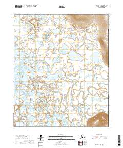
2017 Map of Teller A-1 NE
USGS Topo · Published 2017About this map
Marys Igloo and New Igloo are established along the winding waterways of the Seward Peninsula, highlighting a landscape defined by the shifting courses of the Kuzitrin River and Pilgrim River. The terrain is dominated by vast wetland complexes and thaw lakes, such as Lake Omiaktalik and Marys Lake, which are characteristic of the region's permafrost environment. In the southeast, Marys Mtn provides a rare point of elevation overlooking the low-lying drainage basins. The intricate network of channels, including Davidsons Slough and Grand Union Creek, illustrates the complex hydrology of this part of the Nome Census Area. This 2017 data reflects the sparse settlement patterns and the enduring importance of river access for navigation and subsistence in the Alaskan interior.
Find a feature on this map
13 named features on this map. Tap any name to fly to it.
Don’t see what you’re looking for? This feature index may not catch every label — zoom into the map to look around manually.
Map Details
Editions of this 2017 Teller A-1 NE Map
This is the sole edition of this map. No revisions or reprints were ever made.
Other maps of this area

1950 · Bendeleben A-6
USGS Topo · 1:63,360

1950 · Bendeleben B-6
USGS Topo · 1:63,360

1950 · Teller
USGS Topo · 1:250,000

1950 · Bendeleben
USGS Topo · 1:250,000

1950 · Teller A-1
USGS Topo · 1:63,360

1950 · Teller B-1
USGS Topo · 1:63,360

1951 · Bendeleben
USGS Topo · 1:250,000

1951 · Teller
USGS Topo · 1:250,000

1957 · Teller
USGS Topo · 1:250,000

1958 · Teller
USGS Topo · 1:250,000