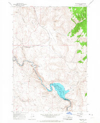
1965 Map of Telocaset
USGS Topo · Published 1967About this map
The Union Pacific railroad corridor defines the development of this eastern Oregon landscape, threading through Pyles Canyon and past the settlement of Telocaset. This mid-century survey captures the rugged transition between the Antelope Valley and the forested slopes of the Whitman National Forest. To the south, the Powder River carves a winding path across the Union and Baker county line, where it is impounded by the Thief Valley Dam to form the Thief Valley Reservoir. Small rail-side points and rural outposts like Sago and Gentry appear alongside varied terrain features such as Telocaset Hill and Riverdale Hill. The map documents a working landscape of the 1960s, marked by scattered Mines, Prospects, and a Quarry, reflecting the area's history of natural resource extraction and transit infrastructure.
Find a feature on this map
32 named features on this map. Tap any name to fly to it.
Don’t see what you’re looking for? This feature index may not catch every label — zoom into the map to look around manually.
Map Details
Editions of this 1965 Telocaset Map
2 editions found
Other maps of this area

1901 · Baker City
USGS Topo · 1:125,000

1906 · Telocaset
USGS Topo · 1:125,000

1955 · Baker
USGS Topo · 1:250,000

1955 · Grangeville
USGS Topo · 1:250,000

1959 · Baker
USGS Topo · 1:250,000

1959 · Grangeville
USGS Topo · 1:250,000

1965 · Union
USGS Topo · 1:24,000

1965 · Medical Springs
USGS Topo · 1:24,000
1965 · North Powder
USGS Topo · 1:24,000

1965 · Little Catherine Creek
USGS Topo · 1:24,000