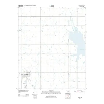
2010 Map of Temple
USGS Topo · Published 2010About this map
The town of Temple serves as the primary hub in this corner of Cotton County, Oklahoma, surrounded by a systematic grid of section roads like Lone Star Rd. The landscape is defined by the expansive western shoreline of Waurika Lake, which dominates the eastern portion of the quadrangle. Local hydrology is further marked by a series of north-south waterways including Whiskey Creek, Mills Creek, and the confluence area of Beaver Creek and Little Beaver Creek.
Find a feature on this map
26 named features on this map. Tap any name to fly to it.
Don’t see what you’re looking for? This feature index may not catch every label — zoom into the map to look around manually.
Map Details
Editions of this 2010 Temple Map
This is the sole edition of this map. No revisions or reprints were ever made.
Other maps of this area

1955 · Lawton
USGS Topo · 1:250,000

1957 · Hastings
USGS Topo · 1:62,500

1957 · Randlett
USGS Topo · 1:62,500

1962 · Walters
USGS Topo · 1:62,500

1962 · Temple
USGS Topo · 1:62,500

1984 · Hooper
USGS Topo · 1:24,000
1984 · Waurika West
USGS Topo · 1:24,000
1985 · Taylor
USGS Topo · 1:24,000

1985 · Burkburnett
USGS Topo · 1:100,000
1987 · Walters NE
USGS Topo · 1:24,000