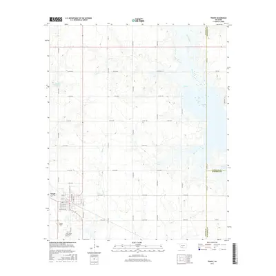
2016 Map of Temple
USGS Topo · Published 2016About this map
Temple is positioned in the southwestern corner of this Oklahoma landscape, defined by a grid of street names including N Commercial Ave, W Main St, and Central St. Just south of the town center, the Temple Cem and Temple Airport Inc sit near the local drainage of Whiskey Cr. The terrain east of town is dominated by the extensive waters of Waurika Lake, which spans the convergence of Beaver Cr and Mills Cr.
Find a feature on this map
41 named features on this map. Tap any name to fly to it.
Don’t see what you’re looking for? This feature index may not catch every label — zoom into the map to look around manually.
Map Details
Editions of this 2016 Temple Map
This is the sole edition of this map. No revisions or reprints were ever made.
Other maps of this area

1955 · Lawton
USGS Topo · 1:250,000

1957 · Hastings
USGS Topo · 1:62,500

1957 · Randlett
USGS Topo · 1:62,500

1962 · Walters
USGS Topo · 1:62,500

1962 · Temple
USGS Topo · 1:62,500

1984 · Hooper
USGS Topo · 1:24,000
1984 · Waurika West
USGS Topo · 1:24,000
1985 · Taylor
USGS Topo · 1:24,000

1985 · Burkburnett
USGS Topo · 1:100,000
1987 · Walters NE
USGS Topo · 1:24,000