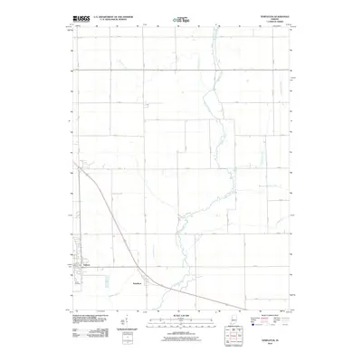
2010 Map of Templeton
USGS Topo · Published 2010About this map
Templeton and the eastern edge of Oxford anchor this rural landscape in Benton County, Indiana. The area is defined by an extensive drainage network developed to support its deep agricultural roots, featuring man-made waterways like Greenwood Ditch, Brumm Ditch, and Ella Brown Ditch. These ditches channel water toward the larger natural courses of Big Pine Creek and Little Pine Creek, which meander through the central and eastern portions of the quadrangle. For those researching local families, Justus Cemetery is located south of Oxford, providing a genealogical landmark within this grid of country roads. The map illustrates the 21st-century configuration of this prairie region, showing the continued reliance on both historical creek beds and engineered drainage to manage the fertile terrain.
Find a feature on this map
35 named features on this map. Tap any name to fly to it.
Don’t see what you’re looking for? This feature index may not catch every label — zoom into the map to look around manually.
Map Details
Editions of this 2010 Templeton Map
This is the sole edition of this map. No revisions or reprints were ever made.
Other maps of this area

1942 · Otterbein
USGS Topo · 1:24,000

1951 · Otterbein
USGS Topo · 1:24,000

1953 · Danville
USGS Topo · 1:250,000

1955 · Danville
USGS Topo · 1:250,000

1956 · Danville
USGS Topo · 1:250,000

1961 · Chatterton
USGS Topo · 1:24,000

1961 · Pine Village
USGS Topo · 1:24,000

1961 · Otterbein
USGS Topo · 1:24,000

1962 · Mount Gilboa
USGS Topo · 1:24,000
1962 · Round Grove
USGS Topo · 1:24,000