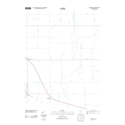
2013 Map of Templeton
USGS Topo · Published 2013About this map
The town of Oxford anchors the southwestern portion of this Benton County landscape, where the residential street grid gives way to a sprawling network of agricultural drainage systems and rural homesteads. This 2013 survey illustrates the heavy reliance on managed waterways in the region, with Greenwood Ditch, Brumm Ditch, and Darby Ditch cutting through the prairie to support the local farming economy. The settlement of Templeton sits at a major transit junction, while the smaller locality of Atkinson is positioned further northwest. Natural watercourses like Big Pine Cr and Little Pine Cr meander through the township, providing a clear contrast between the original hydrology and the engineered channels like Ella Brown Ditch that now define much of the territory's drainage pattern.
Find a feature on this map
42 named features on this map. Tap any name to fly to it.
Don’t see what you’re looking for? This feature index may not catch every label — zoom into the map to look around manually.
Map Details
Editions of this 2013 Templeton Map
This is the sole edition of this map. No revisions or reprints were ever made.
Other maps of this area

1942 · Otterbein
USGS Topo · 1:24,000

1951 · Otterbein
USGS Topo · 1:24,000

1953 · Danville
USGS Topo · 1:250,000

1955 · Danville
USGS Topo · 1:250,000

1956 · Danville
USGS Topo · 1:250,000

1961 · Chatterton
USGS Topo · 1:24,000

1961 · Pine Village
USGS Topo · 1:24,000

1961 · Otterbein
USGS Topo · 1:24,000

1962 · Mount Gilboa
USGS Topo · 1:24,000
1962 · Round Grove
USGS Topo · 1:24,000