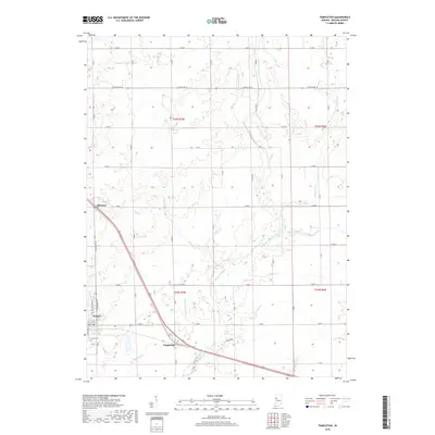
2019 Map of Templeton
USGS Topo · Published 2019About this map
The town of Oxford stands at the western edge of this Benton County landscape, where the rectilinear grid of Indiana's farm country meets the winding path of Big Pine Creek. This 2019 survey documents a rural region defined by its sophisticated drainage network, including Greenwood Ditch, Ella Brown Ditch, and Brumm Ditch, which channel water away from the productive agricultural fields. The settlement of Templeton serves as a small transit hub where Old US Hwy 52 and regional rail lines converge, while Atkinson marks another distinct point of settlement to the northwest.
Find a feature on this map
30 named features on this map. Tap any name to fly to it.
Don’t see what you’re looking for? This feature index may not catch every label — zoom into the map to look around manually.
Map Details
Editions of this 2019 Templeton Map
This is the sole edition of this map. No revisions or reprints were ever made.
Other maps of this area

1942 · Otterbein
USGS Topo · 1:24,000

1951 · Otterbein
USGS Topo · 1:24,000

1953 · Danville
USGS Topo · 1:250,000

1955 · Danville
USGS Topo · 1:250,000

1956 · Danville
USGS Topo · 1:250,000

1961 · Chatterton
USGS Topo · 1:24,000

1961 · Pine Village
USGS Topo · 1:24,000

1961 · Otterbein
USGS Topo · 1:24,000

1962 · Mount Gilboa
USGS Topo · 1:24,000
1962 · Round Grove
USGS Topo · 1:24,000