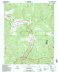
1994 Map of Templeton Mtn
USGS Topo · Published 1997About this map
The South Fork Kern River winds through a high-altitude landscape of sprawling meadows and granite peaks within the Golden Trout Wilderness. This 1990s revision by the U.S. Forest Service documents the intersection of protected wilderness areas and the high Sierran cattle grazing traditions of the late twentieth century. Seasonal outposts such as Templeton Cow Camp and Brown Cow Camp remain as evidence of the area's pastoral history, situated near vast clearings like Templeton Meadows and Strawberry Meadows.
Find a feature on this map
42 named features on this map. Tap any name to fly to it.
Don’t see what you’re looking for? This feature index may not catch every label — zoom into the map to look around manually.
Map Details
Editions of this 1994 Templeton Mtn Map
This is the sole edition of this map. No revisions or reprints were ever made.
Other maps of this area

1905 · Olancha
USGS Topo · 1:125,000

1907 · Olancha
USGS Topo · 1:125,000

1948 · Fresno
USGS Topo · 1:250,000

1955 · Fresno
USGS Topo · 1:250,000

1956 · Fresno
USGS Topo · 1:250,000

1956 · Hockett Peak
USGS Topo · 1:62,500
1956 · Monache Mtn
USGS Topo · 1:62,500

1956 · Olancha
USGS Topo · 1:62,500
1956 · Kern Peak
USGS Topo · 1:62,500

1958 · Fresno
USGS Topo · 1:250,000