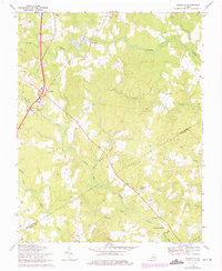
1969 Map of Templeton
USGS Topo · Published 1975About this map
Warwick Swamp and its many tributaries, including Joseph Swamp and Indian Swamp, create a dense hydrological network across this part of the Virginia coastal plain. The settlement of Templeton serves as a central point where major transportation routes converge, surrounded by a rural landscape defined by family-named landmarks and water-powered history. Significant mill sites like Lees Mill and Belsches Millpond reflect the traditional agricultural economy of the region, while a series of community anchors such as Salem Ch, Mt Zion Ch, and Loving Union Ch provide essential touchpoints for genealogical research. The map also captures the local boundary line between Prince George Co and Sussex Co, showing how the terrain of Jones Hole Swamp and Cherry Orchard Branch dictated the placement of early homesteads and crossroads.
Find a feature on this map
26 named features on this map. Tap any name to fly to it.
Don’t see what you’re looking for? This feature index may not catch every label — zoom into the map to look around manually.
Map Details
Editions of this 1969 Templeton Map
2 editions found
Other maps of this area

1894 · Petersburg
USGS Topo · 1:62,500

1919 · Jarratt
USGS Topo · 1:62,500

1919 · Disputanta
USGS Topo · 1:62,500

1919 · Homeville
USGS Topo · 1:48,000

1920 · Homeville
USGS Topo · 1:62,500

1943 · Littleton
USGS Topo · 1:31,680

1943 · Disputanta
USGS Topo · 1:31,680

1943 · Richmond
USGS Topo · 1:250,000

1944 · Reams
USGS Topo · 1:31,680
1944 · Petersburg
USGS Topo · 1:31,680