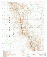
1990 Map of Temporal Pass
USGS Topo · Published 1990About this map
Growler Mountains dominate this 1990 survey, serving as a significant geological divide between the Growler Valley to the west and desert arroyos to the east. The landscape is defined by its administrative complexity, where the Cabeza Prieta National Wildlife Refuge overlaps with the Barry M Goldwater Air Force Range. This intersection of conservation and military utility is marked by the Military Reservation Boundary, showing a terrain managed for both ecological preservation and national defense. Water remains the primary shaper of the lowland topography, evidenced by the drainage patterns of Daniels Arroyo and Chico Shunie Arroyo. At the center of the range, Temporal Pass provides a noted break in the ridgeline, historically significant for movement across this arid stretch of Pima County.
Find a feature on this map
13 named features on this map. Tap any name to fly to it.
Don’t see what you’re looking for? This feature index may not catch every label — zoom into the map to look around manually.
Map Details
Editions of this 1990 Temporal Pass Map
2 editions found
Other maps of this area

1932 · Ajo
USGS Topo · 1:62,500

1934 · Ajo
USGS Topo · 1:62,500

1953 · Ajo
USGS Topo · 1:250,000

1957 · Ajo
USGS Topo · 1:250,000

1958 · Ajo
USGS Topo · 1:250,000

1962 · Ajo
USGS Topo · 1:250,000

1963 · Ajo
USGS Topo · 1:250,000

1963 · Ajo
USGS Topo · 1:62,500

1963 · Kino Peak
USGS Topo · 1:62,500

1964 · Growler Peak
USGS Topo · 1:62,500