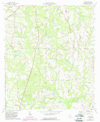
1974 Map of Tempy
USGS Topo · Published 1988About this map
Tempy and Powelltown anchor this rural landscape in Worth County, which is defined by an intricate network of waterways draining toward the Ochlockonee River. The 1974 survey, later updated in 1988, illustrates a landscape of agricultural tradition and dispersed community centers. Local history is preserved in the numerous country churches and burial grounds that dot the terrain, such as Beulah Ch and New Bethel Cem. The drainage patterns of Horse Creek and Warrior Creek have clearly influenced the placement of these settlements and connecting roads. A notable landmark, the Lookout Tower, stands near the southern edge of the map, while a Sandpit near Oak Grove Ch points to local extractive activity. The map provides a high-resolution record of rural land use, showing field boundaries and woodland tracts that characterize this portion of South Georgia.
Find a feature on this map
20 named features on this map. Tap any name to fly to it.
Don’t see what you’re looking for? This feature index may not catch every label — zoom into the map to look around manually.
Map Details
Editions of this 1974 Tempy Map
2 editions found
Other maps of this area

1953 · Waycross
USGS Topo · 1:250,000

1956 · Sylvester
USGS Topo · 1:62,500

1956 · Doerun
USGS Topo · 1:62,500

1958 · Waycross
USGS Topo · 1:250,000

1973 · Sumner
USGS Topo · 1:24,000

1973 · Ty Ty
USGS Topo · 1:24,000

1973 · Norman Park
USGS Topo · 1:24,000
1973 · Acree
USGS Topo · 1:24,000

1973 · Sylvester
USGS Topo · 1:24,000
1974 · Doerun
USGS Topo · 1:24,000