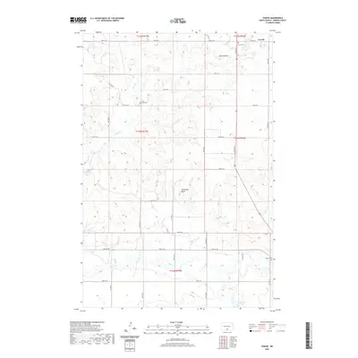
2020 Map of Temvik
USGS Topo · Published 2020About this map
Temvik sits at the northern edge of this landscape in Emmons County, marking a pocket of settlement in the North Dakota plains. The terrain is characterized by prominent elevations such as Temvik Butte and Winchester Butte, which rise above the surrounding drainage basins of Sand Cr and Spring Cr. For genealogists and local historians, several burial grounds are preserved across the sections, including Temvik Cem, the Sand Creek Cem near the central creeks, and the Linton Cem located at the southeastern corner. The map traces the winding course of Beaver Cr through the southern townships, eventually reaching Heidrich Slough. The surveyed grid of township and range lines, such as t133n r77w and t134n r76w, organizes a network of rural roads that connect these isolated landmarks and small homestead clusters.
Find a feature on this map
25 named features on this map. Tap any name to fly to it.
Don’t see what you’re looking for? This feature index may not catch every label — zoom into the map to look around manually.
Map Details
Editions of this 2020 Temvik Map
This is the sole edition of this map. No revisions or reprints were ever made.
Other maps of this area

1954 · Bismarck
USGS Topo · 1:250,000

1958 · Bismarck
USGS Topo · 1:250,000

1971 · Grassna NW
USGS Topo · 1:24,000

1971 · Hazelton
USGS Topo · 1:24,000

1971 · Hazelton SW
USGS Topo · 1:24,000

1971 · Grassna NE
USGS Topo · 1:24,000
1971 · Hazelton NW
USGS Topo · 1:24,000

1971 · Strasburg
USGS Topo · 1:24,000

1971 · Temvik
USGS Topo · 1:24,000

1975 · Appert Lake
USGS Topo · 1:24,000