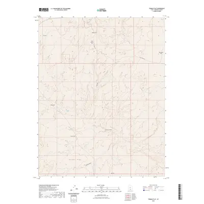
2023 Map of Tenmile Flat
USGS Topo · Published 2023About this map
Tenmile Flat and its surrounding plateau systems in Garfield County characterize this portion of the Utah desert as it appeared in 2023. The terrain is defined by wide, relatively level mesas including Little Spencer Flat, Big Spencer Flats, and Seep Flat, which are dissected by complex drainage networks like Phipps Wash and Cottonwood Wash. These geographical features demonstrate the intricate erosion patterns of the region, where seasonal water flow has carved deep into the elevated flats. Human presence is sparse, anchored primarily by the Old Sheffield Rd, which provides one of the few navigational landmarks through the territory. Significant landforms such as Deadman Ridge and the Halfway Hollow drainage offer clear points of reference for those studying the physical geography or tracing historic routes through this portion of the Escalante basin.
Find a feature on this map
13 named features on this map. Tap any name to fly to it.
Don’t see what you’re looking for? This feature index may not catch every label — zoom into the map to look around manually.
Map Details
Editions of this 2023 Tenmile Flat Map
This is the sole edition of this map. No revisions or reprints were ever made.
Other maps of this area

1886 · Escalante
USGS Topo · 1:250,000

1956 · Escalante
USGS Topo · 1:250,000

1960 · Escalante
USGS Topo · 1:250,000

1964 · Sunset Flat
USGS Topo · 1:24,000

1964 · Tenmile Flat
USGS Topo · 1:24,000
1964 · King Bench
USGS Topo · 1:24,000

1964 · Dave Canyon
USGS Topo · 1:24,000
1964 · Calf Creek
USGS Topo · 1:24,000

1964 · Seep Flat
USGS Topo · 1:24,000

1964 · Carcass Canyon
USGS Topo · 1:24,000