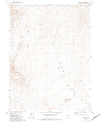
1982 Map of Tenmile
USGS Topo · Published 1984About this map
Selenite Range dominates the western half of this 1980s landscape, providing a stark topographical boundary against the broad expanse of Kumiva Valley to the east. This part of Pershing County is defined by its critical water sources, such as Mud Spring and Antelope Spring, which likely supported the small cluster of activity at Tenmile. The inclusion of a Corral and Water Tank near Tenmile suggests a history of livestock management in an otherwise arid basin. A network of Jeep Trails provides the primary means of traversal through the valley, connecting the high ridges to the southern Twin Buttes. The presence of a Borrow Pit indicates localized resource extraction, perhaps for the maintenance of these remote desert routes.
Find a feature on this map
13 named features on this map. Tap any name to fly to it.
Don’t see what you’re looking for? This feature index may not catch every label — zoom into the map to look around manually.
Map Details
Editions of this 1982 Tenmile Map
This is the sole edition of this map. No revisions or reprints were ever made.
Other maps of this area

1886 · Granite Range
USGS Topo · 1:250,000

1894 · Granite Range
USGS Topo · 1:250,000

1955 · Lovelock
USGS Topo · 1:250,000

1959 · Lovelock
USGS Topo · 1:250,000

1964 · Gerlach
USGS Topo · 1:62,500

1964 · Kumiva Peak
USGS Topo · 1:62,500

1980 · Dry Mountain NW
USGS Topo · 1:24,000

1980 · Eagle Rock Spring
USGS Topo · 1:24,000

1980 · Dry Mountain
USGS Topo · 1:24,000

1980 · Tenmile
USGS Topo · 1:24,000