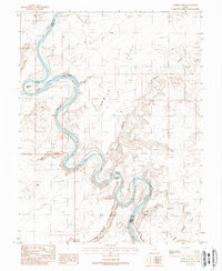
1988 Map of Tenmile Point
USGS Topo · Published 1988About this map
The Green River carves a deep, sinuous path through the high desert of the Colorado Plateau in this late twentieth-century survey. The waterway defines the boundary between Emery and Grand counties, winding through the dramatic Labyrinth Canyon and around the distinctive Trin-Alcove Bend. This landscape is characterized by its isolation and the dramatic verticality of features like Tenmile Point and Keg Point, which tower above the river flats. Along the canyon floor, isolated silt deposits known as bottoms—such as Keg Spring Bottom and Junes Bottom—offered the few areas of level ground in an otherwise formidable terrain. Signs of mid-century industrial exploration are evident at the Hey Joe Mine near Hey Joe Canyon, while natural landmarks like a Natural Arch and the perennial Keg Spring highlight the unique geological and hydrological features of this arid region.
Find a feature on this map
19 named features on this map. Tap any name to fly to it.
Don’t see what you’re looking for? This feature index may not catch every label — zoom into the map to look around manually.
Map Details
Editions of this 1988 Tenmile Point Map
This is the sole edition of this map. No revisions or reprints were ever made.
Other maps of this area

1885 · San Rafael
USGS Topo · 1:250,000

1885 · La Sal
USGS Topo · 1:250,000

1951 · The Knoll
USGS Topo · 1:62,500

1952 · Tidwell 4 SE
USGS Topo · 1:24,000

1952 · Tidwell 4 NE
USGS Topo · 1:24,000

1952 · Moab 3 SW
USGS Topo · 1:24,000

1952 · Moab 3 NW
USGS Topo · 1:24,000

1954 · Tidwell 1 SW
USGS Topo · 1:24,000

1954 · Tidwell 1 SE
USGS Topo · 1:24,000

1954 · Green River
USGS Topo · 1:62,500