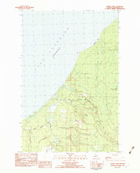
1982 Map of Tenmile Point
USGS Topo · Published 1983About this map
The southern shoreline of Lake Superior dominates this portion of Ontonagon, characterized by a complex network of waterways and a legacy of industrial activity. The landscape is marked by the distinct paths of the Firesteel River, West Sleeping River, and Flintsteel River, which cut through the terrain toward the coast. Evidence of the region's logging or industrial past is visible through a series of numbered camps, including Camp 6, Camp 5, and Camp 7, scattered throughout the interior forests.
Find a feature on this map
20 named features on this map. Tap any name to fly to it.
Don’t see what you’re looking for? This feature index may not catch every label — zoom into the map to look around manually.
Map Details
Editions of this 1982 Tenmile Point Map
This is the sole edition of this map. No revisions or reprints were ever made.
Other maps of this area

1950 · Greenland
USGS Topo · 1:62,500

1951 · Greenland
USGS Topo · 1:62,500

1955 · Ontonagon
USGS Topo · 1:62,500

1958 · Hancock
USGS Topo · 1:250,000

1958 · Iron River
USGS Topo · 1:250,000

1960 · Iron River
USGS Topo · 1:250,000

1960 · Hancock
USGS Topo · 1:250,000

1961 · Iron River
USGS Topo · 1:250,000

1961 · Hancock
USGS Topo · 1:250,000

1966 · Hancock
USGS Topo · 1:250,000