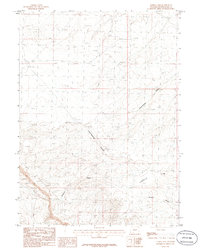
1986 Map of Tenmile Rim
USGS Topo · Published 1986About this map
The Continental Divide cuts a winding path through this high-desert landscape in Sweetwater County, marking the definitive hydraulic break of the American West. This 1980s era survey by the U.S. Geological Survey documents a stark, arid terrain defined by significant geographic breaks like the Tenmile Rim. The drainage patterns here are critical to understanding the local topography, with the seasonal waters of Twelvemile Gulch and Ninemile Wash carving out the land as they head toward the Tenmile Draw. Apart from the township boundaries of T 22 N and T 21 N, the area remains largely undeveloped, showcasing the raw geological character of the Great Divide Basin before modern expansion changed the regional footprint.
Find a feature on this map
6 named features on this map. Tap any name to fly to it.
Don’t see what you’re looking for? This feature index may not catch every label — zoom into the map to look around manually.
Map Details
Editions of this 1986 Tenmile Rim Map
This is the sole edition of this map. No revisions or reprints were ever made.
Other maps of this area

1954 · Rock Springs
USGS Topo · 1:250,000

1958 · Rock Springs
USGS Topo · 1:250,000

1958 · Twelvemile Well
USGS Topo · 1:62,500

1958 · Superior
USGS Topo · 1:62,500

1962 · Rock Springs
USGS Topo · 1:250,000

1968 · Bitter Creek NW
USGS Topo · 1:24,000

1968 · Point Of Rocks
USGS Topo · 1:24,000

1968 · Bitter Creek NE
USGS Topo · 1:24,000
1980 · Red Desert Basin
USGS Topo · 1:100,000
1986 · Black Rock Flat East
USGS Topo · 1:24,000