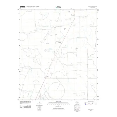
2010 Map of Tennyson
USGS Topo · Published 2010About this map
The small community of Tennyson and the nearby siding at Orient anchor this corner of West Texas, where the landscape transitions between the rolling plains and distinctive limestone-capped mesas. A rail corridor runs north-to-south, marked by Wooland Siding and the narrow passage through Orient Pass, reflecting the vital transport infrastructure that sustained these ranching and farming outposts. The terrain is defined by a series of prominent elevations, including Mount Margaret, Kiser Mountain, and several descriptively named heights like Gobbler Hill and Buttermilk Hill. Local history is preserved in the location of the Mule Creek Cemetery and the remnants of rural infrastructure such as Tennyson School Rd. The drainage network, featuring Mule Creek, Cedar Creek, and Crows Nest Creek, illustrates the essential water sources that dictated early settlement patterns in this semi-arid region.
Find a feature on this map
34 named features on this map. Tap any name to fly to it.
Don’t see what you’re looking for? This feature index may not catch every label — zoom into the map to look around manually.
Map Details
Editions of this 2010 Tennyson Map
This is the sole edition of this map. No revisions or reprints were ever made.
Other maps of this area

1891 · Hayrick
USGS Topo · 1:125,000

1894 · Hayrick
USGS Topo · 1:125,000

1921 · Baker Flat
USGS Topo · 1:31,680

1921 · Maverick
USGS Topo · 1:31,680

1921 · Mays School
USGS Topo · 1:31,680

1954 · San Angelo
USGS Topo · 1:250,000

1957 · Miles
USGS Topo · 1:62,500

1957 · Harriet
USGS Topo · 1:62,500
1957 · San Angelo North
USGS Topo · 1:24,000

1958 · San Angelo
USGS Topo · 1:250,000