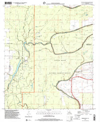
1998 Map of Tensas Bluff
USGS Topo · Published 2002About this map
The Tensas River carves a winding path through this corner of the Louisiana Delta, where the landscape is defined by the shifting hydrology of bayous and sloughs. Near Tensas Bluff, the presence of a Ferry, a small Cem, and a Landing Strip suggests a remote but functional rural hub along the riverbanks. The terrain is deeply marked by extractive industry, with numerous Oil Wells and Drill Holes scattered throughout the wetlands and forested reaches.
Find a feature on this map
33 named features on this map. Tap any name to fly to it.
Don’t see what you’re looking for? This feature index may not catch every label — zoom into the map to look around manually.
Map Details
Editions of this 1998 Tensas Bluff Map
This is the sole edition of this map. No revisions or reprints were ever made.
Other maps of this area

1935 · Winnsboro
USGS Topo · 1:62,500

1935 · Baskinton
USGS Topo · 1:62,500

1935 · Waverly
USGS Topo · 1:62,500

1935 · Shackleford Lake
USGS Topo · 1:62,500

1955 · Jackson
USGS Topo · 1:250,000

1958 · Baskinton
USGS Topo · 1:62,500

1958 · Shackleford Lake
USGS Topo · 1:62,500

1958 · Winnsboro
USGS Topo · 1:62,500

1961 · Jackson
USGS Topo · 1:250,000

1961 · Waverly
USGS Topo · 1:62,500